 Baku and the Absheron peninsula are significant for their historic monuments and defence fortifications. Ancient Baku was surrounded by semi-desert steppe, thus it has managed to preserve its many historical and architectural medieval monuments. The area surrounded by those walls is now called the Old City, but just two centuries ago it was Baku City. The unique system of huge fortified walls and towers was constructed in the Middle Ages. These impressive stone structures have maintained their magnificence in the Old City until today.
 Through the Middle Ages Baku was surrounded by gigantic fortress walls to the north, east and west. These walls were constantly being restored as they were often destroyed during enemy attacks; the last restoration was in 1950 and it left 25 semi-circular towers and one square tower (donjon or storeroom). The towers were built every 12 to 15 metres along the wall and are 10 to 12 metres high. There are thirteen towers along the north and east walls and twelve along the west side. Currently, only 960 of the original 1500 metres of wall remain.
The waves wash its walls…
We owe much of what we know about medieval Baku to the written accounts of Abdurrashid ibn Sabir ibn Nuri al-Bakuvi. He was a well-known traveller, historian and geographer of the East. He lived in Tabriz but was originally from Baku. His book, Review of the Monuments and about the Miracles of the Powerful Ruler is still extant. A copy of the book held in the National Library of France was brought to Azerbaijan by academician Z. M. Bunyadov, where it was translated into Russian and published with his introduction and the Arabic text. Bakuvi describes Azerbaijan’s medieval towns, especially Baku, in great detail.
Describing the city’s fortress walls, he writes:
The city has two strong main towers. The bigger one is near the sea. The waves wash its walls. This was the tower that the Tatars couldn’t occupy. The upper part was unevenly built. The second tower is higher up.
No doubt the first tower Bakuvi mentions is Maiden Tower. And the second is perhaps the Square Tower. This one is situated higher up than Maiden Tower both by geographical position and by city skyline. It is also clear from Bakuvi that Maiden Tower protected the city from the south and the Square Tower from the north.
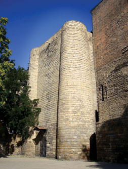
According to the writer there was only one square tower among 70 semicircular towers in Baku’s northern fortress walls. The Square Tower is clearly seen in old photographs, reproductions, and other pictures of old Baku. It was referred to locally as a storeroom and was used as an armoury in the Middle Ages. The tower was built with several purposes in mind. First, to improve the defensive position from the north by making the appearance of the fortress walls more impressive. Second, to use the tower, which is large and enclosed, as an armoury.
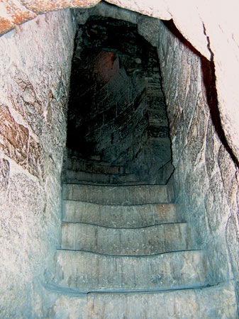 Upper staircase in thr Square Tower
The donjon
This Square Tower is also called the donjon (or dungeon, from the French word meaning ‘heavily fortified central tower’). It is similar to those at Mardakan and Ramana and is a classic example of Absheroni defensive systems. It has four floors: three of them are enclosed and one is open. It is 18 metres high, and the walls are 2 metres thick. The corners of the tower are 2.5 metres in diameter. Its cylindrical corners give it its impressive appearance. There is a spiral staircase in the corners of the rooms. Local limestone was used in its construction.
This tower was probably surrounded by walls as is typical of Absheroni towers. This can be seen in a picture painted by the architect Sheblikin in 1941. We also find this tower in a picture painted by the German traveller Engelbert Kaempfer in 1683. The tower appears in a map drawn by hydrographic engineer Christian Ivanovich Truzson in 1796. It was pictured again in the map of Baku drawn by hydrographic Captain-Lieutenant A. F. Ulskiy in 1858-66. The tower is situated along the paths for the movement of fortress defenders in the north walls. There is a belief that underground passageways linked the tower to the Shirvanshah’s Palace, Maiden Tower and the Double Gates. Of course, this would allow soldiers to easily carry weapons from the castle. The tower served as security for the Shah’s family.
Badr Shirvani, who lived in the late 14th and early 15th centuries, was a court poet. He described the strong fortress walls and towers of Baku in a poem of praise to Lele Edi, the Shah’s nanny.
Turkish traveller Evliya Chelebi, who was in Baku in 1647, described 70 semi-circular towers and more than 600 loopholes in the fortress walls in his Travel Book. According to him, the wall was built on rock and reached a height of 40 dirseks (1 dirsəк = 0.5 metres). Archaeological excavations later proved that the walls actually were built on rock.
Both fortress walls and city buildings were reflected in the plan The Situation of Baku Fortress, depicting the city in 1738. This document is housed in the Moscow State Central Military and History Archive. The map shows how Baku fortress was strengthened with six bastions between 1723 and 1738. In the plan the bastions were referred to as Russian Gate, Azov Bastion, Petersburg Bastion, Moscow Bastion, the Bastion in front of the South-East Gate and Felmans. One of the bastions is believed to be situated just behind the Square Tower, currently in the yard of the Administrative Board of the Academy of Science.
There are two theories about the history of the building of the Tower. Some scholars say it was built at the same time as the fortress walls, i.e. in the 12th century. Other researchers claim it was built in the late 14th and early 15th centuries in a peaceful period for the Shirvan state. A. G. Rahimova, in her article On the Construction History of Certain Architectural Monuments, published in 1971, claims that the Tower was built in the 15th century. This is most probably true. Badr Shirvani, the court poet to the Shirvanshahs, wrote in his poems that some buildings, including the Tower, were built in 1428-29 to strengthen the city from the north by Gazanfar Shah (1398-1443), the ruler of Baku and brother of Shirvanshah Khalilullah I.
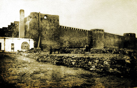 The Square Tower, photograph. 1890
Restoration…
The Square Tower, standing in the line of the northern fortress walls, still preserves its grandeur and magnificence. Conservation works are currently underway on the Tower. The interior was cleared of all unnecessary constructions. Archaeological excavations have been conducted on the ground floor, during which some artefacts were found.
The artefacts included flasks and aftafa (jugs), as well as a large number of fragments of clay pots and 25 rifle bullets (used and unused) from the early 20th century. The layers of soil were removed until the rock and a well were exposed. A sanitation system was found on this floor. Cleaning the walls revealed air ventilation holes which had long been covered under a layer of wall.
In the course of this complex technological process, carried out in several stages, approximately 500 square metres of surface cover were preserved with special equipment and materials. Not a single stone fell from the Tower during restoration and no damage was done to the historic character of the monument and its existing shape. Thus, the project adhered to strict international standards for the preservation of historical monuments. When the conservation work is complete, the Arms Museum exhibition will be created inside. The restoration of a tower in the north-eastern fortress walls, which was pulled down during a reconstruction and never restored, is also on the agenda.
During the restoration in 1950 one of the other semicircular towers near the palace was not restored and was lost. This removal of the lost tower from the walls was the result of chaotic and unplanned construction in the area in the early 20th century.
…from historical plans
The lost tower is clearly seen in photographs of the first line of the northern walls from the inside, taken from different perspectives by photographer F. I. Shreibor at the beginning of the last century. When researching the history of this monument a map, whose original is in the Historical Museum of Military Engineering in Moscow, attracted our attention. The lost tower is clearly seen on this map drawn by Engineer-Colonel Kovalerov in 1796, exactly as it was before being pulled down.
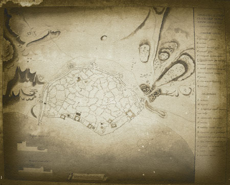 Map compiled by hydrographic engineer Colonel C.I.Truzson. 1796
During the latest restoration carried out on the north-eastern fortress walls by the Administration of the State Historical Architectural Reserve of Icheri Sheher, craftsmen worked from the maps drawn by Russian engineers in the late 19th and early 20th centuries. This impressive tower in the north-eastern fortress wall has already been restored with the latest technology. It now appears as it did when originally constructed.
The professional conservation of the second tower in Icheri Sheher and the establishment of a museum will be a gift to the people of Baku. This wonderful example of Shirvan-Absheroni architecture will be passed on from our grandfathers to future generations.
Bibliography
1. Rzayev N.Ş. Baкı qülləsi//Elm və həyat jurn., № 2, 1995
2. Ахундов Т.И. К датировке крепостных стен Ичеришехер. Страницы истории Баку и Апшерона. Баку, 1990
3. Ашурбейли С.Б. Государство Ширваншахов.Баку, 1983.
4. Ашурбейли С.Б. История города Баку. Баку, 1992.
5. Керимов В.И. Оборонительные сооружения Азербайджана. Баку, 1998.
6. Пахомов Е.А. Старинные оборонные сооружения Апшерона//ТИИ им. А.Бакиханова, т.I, Баку, 1947.
7. Рзаев Н.И. Северные ворота крепостных стен города Баку//Памятники архитектуры Азербайджана. Баку, 1950.