 Part of Parapet Square, 1930s (now Nizami square)
 Pages 24-27
by Kamil Farhadoglu
Baku’s incorporation into the Russian Empire in 1806 marked the start of a new phase in the city’s development, both in terms of layout and architecture. The city changed even more dramatically after it was given the status of a governorate in 1859.
The buildings of the day and the street plan restricted the scope for creativity, but the city’s architects still managed to develop an esplanade (a large open area between the fortress walls and nearby urban buildings which could be used to defend the fortress) and some elements that subsequently became architectural features. These were Kolyubakinskaya Square, or the Parapet, (the present-day Fountains Square) not far from Shamakhi gate, and the wasteland on the site of the future Molokan Gardens. The neighbourhoods around the fortress were built to fit the contours of the fortress walls; the streets were linked to the towers, as though to supporting elements that connected the ancient and modern parts of the city. Swans swam in the gubernatorial garden, while the Parapet was in an unsightly state and the townspeople demanded that it be turned into a park. In 1891, city architect A.S. Kandinov submitted the design of the Kolyubakinskiy Garden. Kandinov’s project fitted the pattern of pedestrian movement in the city very well. The city Duma (or council) suggested dividing the garden into four parts. There was no greenery in Kolyubakinskaya Square. It was
 The main street between Parapet and the two-floor caravanserai by Azerbaijani Architect Gasim Bei Hajibaba-beyov (now the “Araz” Cinema). 1868"
 Created later than other city parks, the garden in the Parapet showed that the city authorities were losing interest in planting vegetation in the city by the end of the 19th century.
Individual buildings in different compositional styles, depending on the tastes of the customer or architect, sprang up in different parts of the city. Normally, owners and architects wanted to highlight the architectural features of their house. The few squares and gardens that had formed over time were the foundation of the layout of the centre of Baku. The impact of Baku oil on the economy of the region, the attraction of foreign money and the rapid growth in population meant that a Vorstadt, or town beyond the city walls, was needed. The city centre gradually shitted to the Vorstadt. The new squares did not show any clear idea of urban planning. Sobornaya and Birjevaya squares (present-day Sahil Park), the Parapet and the Mariinskiy (Molokan) Garden were in the centre. They can be linked by a thread, as it were, and are bordered to the north by Kolyubakinskaya Street (present-day Nigar Rafi bayli), to the south by Vrangelskaya Street (present-day Ahmad Javad), to the west by Birjevaya (present-day Uzeyir Hajibayov) and
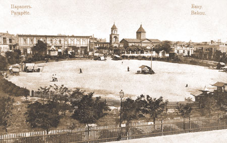 Parapet Square. 1891
 Because the neighbourhoods were not designed properly, Duma Square (present-day Youth Square, outside the Qosha Qala double gates into the Old City) and the Parapet ended up being cut off from the the Mariinskiy Garden and Birjevaya Square. There was no clear connection in terms of the architecture and layout with the historical core of the city – the Icheri Sheher – or with the building materials used in the Vorstadt. The different elements of the city worked in isolation from each other, although they were separated by small distances. This disunity among the major components of the city caused disharmony in the overall composition of the centre, although a developed core could have been created that would have formed a compositional whole.
Small residential neighbourhoods, the build-up of which was not effectively regulated by the overall city layout, dominated the Vorstadt. Major compositional elements of the central part of the city, such as the seaside boulevard, the Parapet and Teatralnaya squares (present-day Neftchilar Avenue) and Mariinskiy Square, and to some extent even the Tsitsianov Gardens, which are now gone, ended up within this bourgeois district.
The appearance of squares in the Vorstadt is closely related to the socio-economic life of the city. Some squares appeared as a venue for parades (Parapet), others as marketplaces (Kubinskaya, Vorontsovskaya).
The boundaries of squares were usually thoroughfares which created an impression of openness. But these streets were not presentable and in no way did they have the usual significance of squares, in terms of town-planning, in the structure of the city. For example, the street that served as a northern boundary of Sobornaya and Birjevaya squares, the Parapet and Mariinskiy (Molokanskiy) Garden, had no clear compositional structure and remained local in the overall city system of streets and mains which were independent within the layout of the city, although they were close to each other.
 Parapet Square. The Square Lusavarich Church, which was built in 1871, in 1873 a school and a libarry were built in the church yard
 Only the Parapet and Gubernatorskaya squares (present-day Vahid Park) were connected with the seaside and Mikhaylovskaya (present-day Injasanat Street) on one side and with the Sadovo-Nikolayevskaya main road on the other. According to this idea, this street that served as a northern boundary was supposed to end in Vorontsovskaya Square (Komur Meydani) and in the south in the sea. However, in the north, in the Shamakhinka area, the artery stopped growing, as it was cut off from Vorontsovskaya Square by rectangular transverse neighbourhoods.
The work of one of the first Azerbaij ani architects of the modern era, Qasim bay Hajibababayov, can be seen in the Parapet. In 1868 he built two-storey caravanserais there (the present-day Araz Cinema and Nizami Literature Museum), residential houses for himself and the Grand Hotel and Metropol Hotel. Qasim bay Hajibababayov was so skilful at urban planning and created the neighbourhoods so well that he more than once drew admiration from Russian and European town-planners.
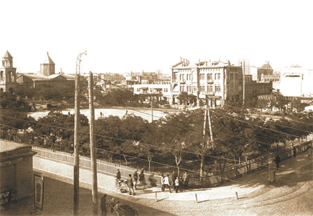 A view of Parapet Square from Gasim Bei Hajibaba-beyov´s caravanserai. Hotels "Grand Hotel" and "Metropole" are behind Parapet. Parapet. 1900s
 The different sizes and appearance of the buildings around the square nonetheless facilitated the creation of a considerable component in the urban planning of turn of- the-century Baku.
Other architectural features near Parapet Square include the St Gregory the Illuminator (Grigor Lusavorich) Church which was built in 1871. The original plan was to build an Aleksandr Nevskiy Orthodox Church on the site but, the site turned out to be too small for the project. In 1869, Baku military governor Mikhail Petrovich Kolyubakin alloted land for the building of the church. The architect of the building was K.K. Gippius, architect of the city of Baku and of the governorate, and brother of the famous artist Otto Gustavovich Gippius (Yevstafiyevich). The grandson of a Lutheran pastor, K.K. Gippius dedicated most of his life to the construction of churches.
His first work was the St Charles Church in Tallinn and second was the church in Baku.
In 1873, a school and a library were built in the courtyard of the church.
A hexagram, the star of David, was imprinted on the facade of the church.
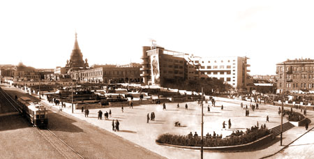
 The lower street in Parapet. 1917
 In the 1930s the entire Parapet was reconstructed.
Opposite the Parapet, across Nikolayevskaya Street (present-day Istiqlaliyyat Street), Sabir Park was set up. As for the Parapet, it was divided into two parts. In the upper part, the Nizami Park was established (opposite the Nizami Museum) and in the lower part –Fountains Square
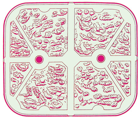 Design for Kolubakinsky Square. Architect: A.S. Kandinov. 1891
 The Parapet Square and Garden, which appeared in the early 1860s, were the organizing element of the business and public centre of Baku. Its axis-like and strictly symmetrical composition determined the location of one of the fi rst and main streets of the Vorstadt.
